
Dean Beattie and, inset, drugs and cash that were seized by Gardai
Search
21 Apr 2026
Please allow ads as they help fund our trusted local news content.
Kindly add us to your ad blocker whitelist.
If you want further access to Ireland's best local journalism, consider contributing and/or subscribing to our free daily Newsletter .
Support our mission and join our community now.
To continue reading this article, you can subscribe for as little as €0.50 per week which will also give you access to all of our premium content and archived articles!
Alternatively, you can pay €0.50 per article, capped at €1 per day.
Thank you for supporting Ireland's best local journalism!


The UK is due to be hit by gale-force winds of up to 80mph as the first named storm of the season approaches.
The Met Office has issued a number of weather warnings ahead of Storm Amy, which is expected to bring “very strong winds and heavy rain” to northern and western areas.
Yellow weather warnings for wind are in place for Scotland, Northern Ireland and parts of north and north-west England on Friday and Saturday, including a risk of danger to life.
The first named storm of the 2025/26 season will see gusts widely reaching 50 to 60mph in northern Britain, potentially reaching 70-80mph in places.
Stronger gusts are expected on exposed coasts and hills, mainly in the north west.
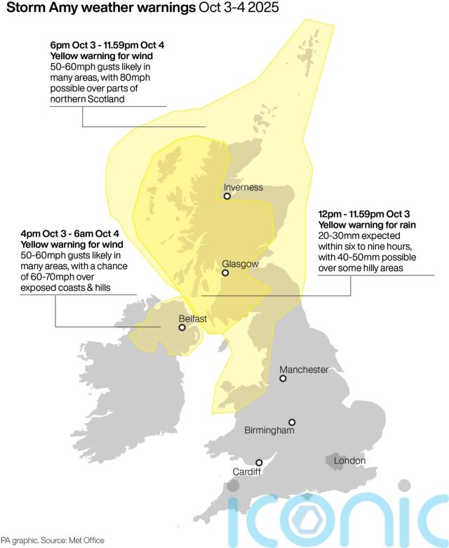
Heavy rain is also expected, particularly over western Scotland, which could see up to 50mm fall in nine hours.
The Met Office is warning of potential disruption to transport, power supplies, and outdoor activities, especially from Friday evening into Saturday.
Met Office deputy chief meteorologist Tom Crabtree, said: “Although there is still some uncertainty about the exact track Storm Amy will take, the system will bring gale-force winds across northern and western regions.
“Heavy rainfall is also expected, particularly over western Scotland, where totals could exceed 30-50 mm in six to nine hours, increasing the risk of localised flooding.
“Forecasts and warnings will be updated as the situation becomes more clear, therefore it is important to keep an eye forecast for your area over the coming days.”
Martin Thomson from Transport Scotland said: “Storm Amy is set to bring heavy rain and strong winds to parts of Scotland and we expect to see disruption to the transport network in the warning areas.
#StormAmy has been named and is forecast to bring strong winds and heavy rain to the UK later on Friday and into Saturday #WeatherAware pic.twitter.com/x5RCePczbV
— Met Office (@metoffice) October 1, 2025
“The rain and wind will bring difficult driving conditions, such as reduced visibility and surface water, and are also likely to affect the ferry and rail networks, so it’s important to plan your journey ahead of time.
“Motorists should use the Traffic Scotland website before they set off to make sure that their route is available, and you should check with your operator if you are planning to travel on trains, ferries and flights.”
A yellow rain warning is in place for heavy rain which is continuing to affect western Scotland throughout Wednesday and Thursday.
A yellow warning for wind has been issued for Scotland, parts of North West and North East England, north Wales and Northern Ireland, between 6pm on Friday and 11.59pm on Saturday.
RAC breakdown spokesman Simon Williams said: “The combination of high winds and rain will make driving treacherous. We strongly advise only making journeys that are absolutely essential.
“Anyone who has to brave the conditions in the worst-affected areas will have to contend with gale-force gusts, surface water that lengthens stopping distances and floods that pose a risk to life and could cause catastrophic vehicle damage.
“The strength of the wind will also inevitably lead to dangerous debris on the roads. Staying put until conditions ease is the best advice.”

Subscribe or register today to discover more from DonegalLive.ie
Buy the e-paper of the Donegal Democrat, Donegal People's Press, Donegal Post and Inish Times here for instant access to Donegal's premier news titles.
Keep up with the latest news from Donegal with our daily newsletter featuring the most important stories of the day delivered to your inbox every evening at 5pm.
This publication supports the work of the Press Council of Ireland and Office of the Press Ombudsman, and our staff operate within the Code of Practice of the Press Council. You can obtain a copy of the Code, or contact the Council, at www.presscouncil.ie, Lo-call 1800 208 080 or email: info@presscouncil.ie.


")


